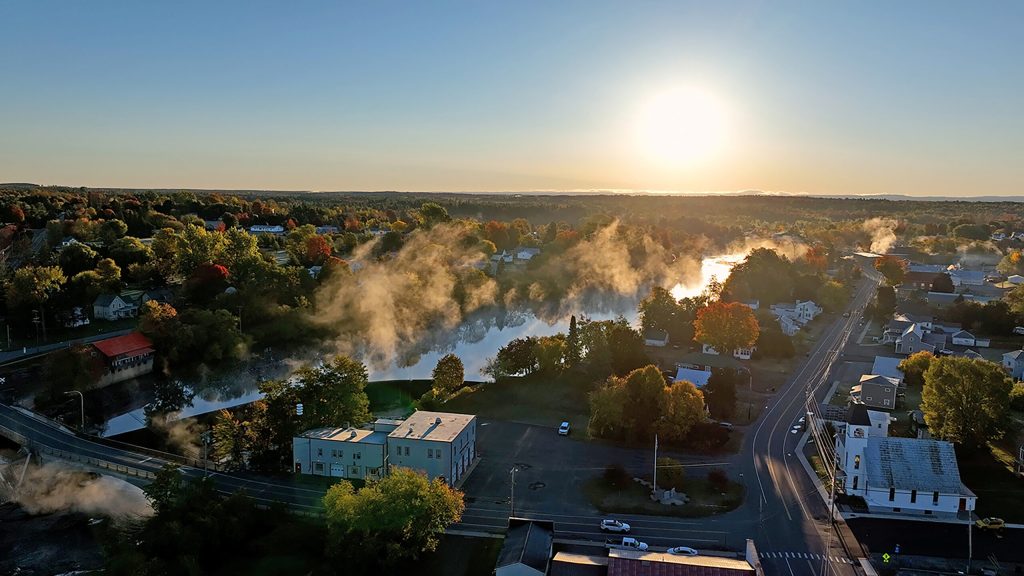
In my hometown there are some left turns down in the village. I think about their order as I mentally ride my bike through the downtown section. I ride across the bridge watching the traffic looking down at the rocks underneath the bridge. The river is shallow there. The first left turn is Island Street because it brings you out on an island where a few old bridges used to be, now there are a couple of houses. They are right out there almost in the river. The power station was built near there. Once you get over the bridge, the next left turn is Crabb Street.
There is a Crabb family that used to run the hardware store (A. B. Crabb) when I was a child. My best friend and I would ride our bikes down there to see the taxidermized (I think I may have made up that word) 2 headed calf and the gigantic moose with widespread antlers.
The next left turn is all the way down by the funeral home and that is Wheeler Lane now known as Wheeler Drive. It leads up to the Catholic Church (of the Visitation of the Blessed Virgin Mary) and goes by my old grade school on the elementary side. I say old, because it was closed when they built a new one attached to the High School. This one is now apartments.) It leads to the old dairy and the water tower out in the fields there. I remember our kindergarten class walked there one hot day in spring. Doctor Wheeler is the person the lane is named for because he invented a new kind of milk bottle back in the day involving sterilization to prevent disease. We got milk in little glass bottles delivered from Wheeler dairy to our kindergarten room. Cream on top, fresh and cold; Paper straws in a big white box. A nice cookie and milk break mid-morning. Very refreshing.
The next left turn is Hepburn St. There is an historic Wesleyan church on this corner, and it is where the Hepburn library stands, and further up you can go by the grade school on the other side. This library always gives me butterflies in my stomach especially the upstairs part. When I was 8 my mom took me to get a book and it was called Stars for Cristy. It got lost among the books we already had- and no one took me back to return it. Eventually forgotten, years went by. I never even read it, to this day. And now I don’t know where it is, and I feel such Catholic guilt because I never returned it. The fine for tardy books must be in the millions of dollars by now. Also, my Girl Scout troop met every Tuesday in the basement, which later became the temporary post office after the post office burned down. There is a winding staircase that we would sneak up, just to see where it went. Much creaking of stairs and whispers between me and my friend. We never made it all the way up. We heard noises and chickened out. Later I found that it led to the main library room.
The next left turn is Bank Street, because of obvious reasons. I’m not sure whether that bank is still open. It was the first bank I had an account then and was quaint and old fashioned with the counter and the caged teller stations with brass fittings. I could see the giant safe back behind the bars. My nose came to the edge of the counter as I slid my bank look across and deposited my $5 allowance.
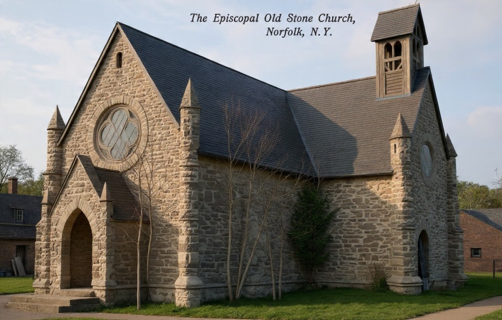
I know there used to be a large stone church there on the east side of Bank Street, but in 1915 most of the village burned and that was one of the treasures lost in time.
Here is a picture of the church, circa 1910.
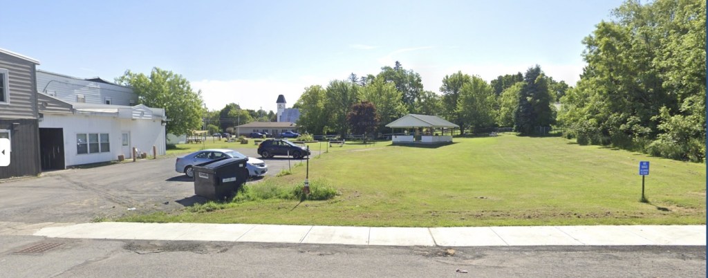
And this is how the lot looks today:
The next left turn is Hutchins Street. (I think. …I’m a bit fuzzy on whether Hutchins comes before or after Bank.) This street was primarily developed post-World War II, with residential homes. I have a deficit of memories about, or on Hutchins St. Of course, this all depends on which direction you are riding your bike. I am remembering riding toward the west.
After Bank Street is Sober Street. That is the one that becomes the River Road. I think the name has something to do with the fact that there used to be more bars than churches in the village. Or maybe this street had no taverns on it; anyway a name ironically chosen with tongue in cheek amusement.
It follows the river, and at one time it was the main road. It led to the paper mill crossing over the village and workers used to walk across on a footbridge to get to work. The River Road is long and winding, and after they built the state route 56, River Road became less used and the paper mill went in and out of use throughout the years. It is working now, I think — but am not sure. Alas, the paper mill is a right turn so does not count in my left turn recollections.
The next left turn is a little street that led to a classmate’s house, which I only remember once attending a pajama party there, and there is a restaurant on the corner. It’s still there. The street bares the same name from the old 1850s map, Second St., and is a dead end. It winds up around the Catholic cemetery, just beyond. it is a place where many of my relatives are buried my maternal grandparents included.
After that the main street, surprisingly called Main Street, travels up a steep hill and curves to the left on the way out of town.
By Diane E. Dockum
April 4, 2026
